DISCLAIMER

**The key word in the header above is hypothetical. I am no globetrotting geriatric, and this is a project for science class.
With that in mind, enjoy my blog!**

Hanga Roa, Easter Island

Latitude: 27° 8'59.97"S
Longitude: 109°25'59.65"W

          So maybe I am not as close to a tectonic boundary as I should be, but somewhere in this trip I just had to indulge myself.
          Come on, people. Cut the old lady some slack. This is Easter Island.

          I repeat. Easter. Freaking (excuse my French). Island.

          This was by far the most excited I have ever been to visit a place. By itself, it is just a lonely little speck in the ocean, comprised mostly of rugged hills covered with wiry grasses. It has a measly area of 63.8 square miles and a population of 5,806 (last time I checked), almost all concentrated in the city of Hanga Roa that I am staying in. No one that I've met so far speaks English - I had to blunder my way through the streets and show the taxi driver the address to my motel in Rapanui. The beaches are rather grainy, with none of the elegantly swaying palm trees I saw in Palau, but rather their stunted dwarf children. It doesn't help that the overcast sky looks like a solid bank of iron, and that the ocean is a matching lackluster gray.
          A tiny, sleepy, remote patch of rock belonging to Chile - but with the most singularly amazing ancient structures in the world.

          I didn't linger in the motel after I checked in - instead, I headed straight for Rapa Nui National Park, home of the monolithic statues called moai. After more blundering for the directions that wasted at least an hour, I arrived at a hillside similar to the one in the picture, and promptly had an attack of shivers running down my spine like a trickle of ice water. 
© 2005 Martin Grey
           I was staring into the blank eyes of a colossal stone head towering nearly 20 feet above me. Its nose was strong and hooked, its mouth was set in a straight line, its face was elongated and flat, tilted slightly upwards, and gazing into the distance with a most unsettling expression that was dead and mournful and proud all at the same time. A king's head, I thought.
           And such silence. Never has so much been conveyed by a lack of sound. The statue took on an enigmatic quality now, a hint of stories long lost to time, witnessed by these empty sockets that could never be imparted to any other. 
          I saw many more all around the park, including a row of fifteen all facing inland with their backs to the sea, eerily standing guard. However, I think of the first one I saw as the King of Moai, guardian of the island's secrets, the forgotten history of an ancient people. Of course, that's just the girlish foolishness and romanticism coming out in me, but it is impossible to convey the awesomeness of these statues through a blog.
          Definitely a must-see for any inhabitants of planet Earth. I can die in peace now.

          I can almost feel your angst as you read this post. "But Hannah! No one wants to hear you wax eloquent on the grandeur of Easter Island! We want science! Where's the science?!"

© 2009 Different Directions
          Pipe down, amigos. A few hundred miles east of Easter Island is the boundary between the Nazca and Pacific plates, where they are neither moving towards or against each other, but pulling apart. As the gap between the two widens, magma rises up and flows through this gap, then cools, rather like the formation of volcanic island arcs. The result is a mountain range that doesn't break the surface of the water, called a mid-ocean ridge, with a crevice in the middle that's called a rift valley.
          And that is the basic explanation for the fourth and final type of tectonic boundary, the divergent boundary. Too bad I don't have access to a submarine to take me down to that mid-ocean ridge, because divergent boundaries have a fascinating feature. From the inside of the Earth comes not only magma, but chemicals and gases that escape in the form of hydrothermal vents. Around these vents are unique biological communities unlike any other, full of chemosynthetic bacteria and tube worms, and all utterly independent of the Sun for survival.

          I feel obliged to attach a third picture. Below is a divergent boundary in Iceland, and one of the few on Earth above water. The rift valley has widened enough for a road to snake through.


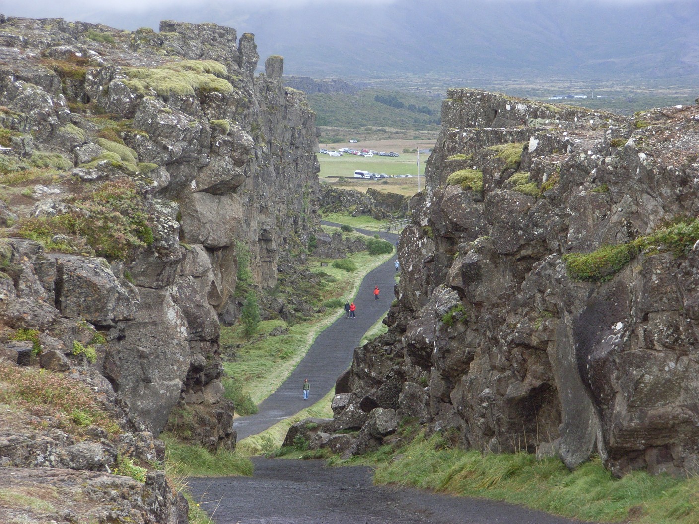
https://sites.google.com/site/midoceanridgesandiceland/effects-of-a-divergent-boundary
 (I couldn't find the copyright)

           That...I think that is just incredible.

           As amazing as Easter Island is, my stay here is tainted with melancholy. This is the last stop of my fabulous tectonic journey. Next week, I will board a plane back to rainy old Seattle (which, incidentally, is near a subduction boundary), and I don't see a second world tour anytime in the near future. So this is it, dear friends. Parting is such sweet sorrow. Only four posts, but I hope you had fun reading them, or learned something new, or were inspired to do some tectonic research on your own. Then again, you probably don't need that inspiration if you were geeky enough to follow a blog on PLATE TECTONICS written by A RETIRED OLD WOMAN who cannot call herself even an amateur geologist. (Or maybe you are just middle school students who had to make similar blogs of your own and comment on others'. Just taking a wild guess here.)
           Okay. Enough's enough, Hannah. Stop dragging out the goodbye. Why, thank you for that reminder, self! But yeah - stay geeky, y'all. Live long and prosper.

© 2010 Solution Bridge, Inc.
           Finis.


Taft, USA

Latitude: 35° 8'32.86"N
Longitude: 119°27'23.57"W

          So.
          Airsick.

          Huuuurgh.

          That was the ugly sound of an old lady dry heaving, after she's already thrown up everything in her stomach. The plane ride felt more like a prolonged roller coaster, and even worse, one of my knees randomly decided to really act up, so there was the humiliation of asking the teenage boy next to me to "assist the elderly". It didn't help that Taft was about 90 degrees and that my taxi driver zipped through the streets at least 15 mph faster than the speed limit. He nearly careened into a pedestrian and had to slam on the breaks with both feet, resulting in me almost strangling on my seatbelt. When I finally dragged myself into the Holland Inn and Suites, I was a total wreck.
          But anyways. I'm back on native soil, but after Kathmandu and Koror, Taft is really nothing to look at. It's a small town, with some areas that wouldn't look out of place in an Old West movie, and right in the middle of the part of California that is arid desert, with scruffy vegetation and parched earth. Everyone parks their cars under the shade of what few trees there are. In the distance are the Sierra-Nevada mountains, but when you've seen the Himalayas and how they glow the colors of fire during sunset and sunrise, these just look...dusty.
          Why do humans choose to develop civilizations in places like this? Did they want to slowly broil to death or shrivel up like a leaf? Surely it was difficult to get anything done with such a barren wasteland before modern times. 
© 2013 Tangient LLC
          There's not much more about Taft to discuss, so I'm going to cut to the chase and educate you with my necessary bit of science. A transform boundary, the third type of tectonic boundary, is when two plates are simply sliding past. Just that: they move in opposite directions and rub against each other.


          And near Taft is one of the most famous transform boundaries in the world: the San Andreas fault, definitely an excellent redeeming feature of this area.


© 2011 Friday Fun Facts
          Now that's cool. You actually see the crevice between the North America and Pacific plates, the divide between two giant slabs of the surface of the planet! (On the flip side, the website I took the picture from called it "California's Butt Crack". Young people these days have no appreciation whatsoever.) And while other transform boundaries have remained inactive for centuries, the San Andreas fault moves up to 5 centimeters a year. Of course, that means earthquakes. Remember the demolition of San Francisco in 1906? It shouldn't come as a surprise then that San Francisco is also located near this boundary. Taft is often rocked by earthquakes as well - the people here may have felt tremors only last week, from a 3.6 Richter scale magnitude shock in Carpinteria.

           Argh. I booked one week at each destination, and while that's been nice enough in Nepal and Palau, there are only so many times I can gaze upon the mightiness of the San Andreas fault. So I guess that's it, fellow readers - I'll see you soon if I haven't succumbed to heat stroke or something.

Koror, Palau

Latitude: 7°20'31.00"N
Longitude: 134°28'45.00"E

           Quick poll: Who among you, of my scant readership, has ever heard of the country called Palau?

           No one, right?

© 2010 Matthias Schulz
           Well, neither had I. While struggling to find a suitable location near an oceanic subduction boundary (more on that later), I just barely noticed this tiny island jutting out of the Pacific, several hundred miles to the east of the Philippines. Amazing thing, this Google Earth. It was pretty much on a whim that I decided to make it the second stop of my tectonic journeys around the world. But lo and behold, after a week in Nepal, befriending Sherpas and reveling in the abundance of gorgeous temples, here I am in the city of Koror, only slightly jet-lagged this time. And my room in the Palau Water Paradise Hotel and Spa overlooks a life-size postcard! Tropical forests roll into the distance; palm trees frame the beach; waves tumble onto the ivory sands; coral atolls speckle the sparkling sapphire sea. There are even huts with thatched roofs inhabited by native families, friendly folk with olive skin and white smiles. Not a lot of urbanity, even in the heart of Koror, but that would only mar this sunny perfection. Really, it's about as idyllic as it gets - like Hawaii, only less crowded. All I need to complete this picture is the twang of a ukulele.

           So where's the science in this? What does this have to do with plate tectonics?
           Some years ago, Rep. Hank Johnson of Congress stated his fear that the small island of Guam would tip over and capsize if overpopulated. Let me clarify something for you: an island is not a floating land mass bobbing in the ocean like a cork. It is the summit of an underwater mountain that has jutted out from the surface of the water, mountains that would dwarf Everest if their bases were at sea level. None of them are planning to capsize anytime soon.
          With that in mind, Palau is located right where two oceanic plates, the Philippine Sea and the Caroline, are converging. This is somewhat different than the interaction between the Indo-Australian and Eurasian plates, because the Caroline plate is actually being forced beneath the Philippine plate, or subducting. The crack between the two becomes a deep-sea trench - the Palau Trench. As the Caroline plate sinks deeper, the water it brings lowers the melting point of the mantle, or the layer of the Earth beneath the crust. Melting mantle becomes magma, and this magma rises up through the Philippine plate, cools, and forms a volcano. A chain of such volcanoes are formed, in fact, and this feature is called a volcanic island arc. If a tip sticks out of the water, it becomes an island, and Palau is one such tip. Yes, I am vacationing on a volcano right now - but so is anyone in Hawaii or Indonesia, just to name a few.

          That, my friends, is a subduction boundary. Your brains fried? Maybe I should just explain with a nice diagram:
© 1984 Tasa Graphic Arts, Inc.
          Like Kathmandu, Palau's location subjects it to frequent earthquake activity. A sizable quake - 4.6 on the Richter scale - occurred only last month, though nothing devastating has happened for a while. And the island itself is dormant, a good thing too, because this trip is supposed to be a learning experience, not a near-death one. Could you imagine how terrifying it would be if you were chilling on some island and it BLEW UP?

          That's all for today, folks. The sea beckons - I'm off to snorkel in the shallows and see fish and turtles and all that wonderfulness. Ak morolung!

Kathmandu, Nepal

Latitude: 27°41'60.00"N
Longitude: 85°19'60.00"E

          The clock on my nightstand says 10 PM, but the time difference between here and Bellevue is almost exactly 12 hours. I write this now, because there's no way I'm getting any sleep anytime soon.

          When you have lived your life - your entire life of 67 years - amongst orderly rows of houses, pruned trees, and roads and roads of cars, then board a plane for 16 hours and arrive at Kathmandu...
          You can't even...
          I can't even...

          Sitting for 2/3 of a day stiffened my knees something awful, but I quickly forgot about that as I hobbled out the airport and hired a bicycle taxi to take me to the hotel, because this city is just so different. No sleek skyscrapers or tidy homes rose up to greet me, but wooden apartments with laundry hanging from the balconies and street vendors in stalls shouting in Nepali. The roads are truly a hazard, a mass of pedestrians, cyclists, carriages, and trolleys sharing a single strip of cement and fighting for their right of passage. We passed majestic stone pagodas on the banks of a river - the temple of Pashupatinath, the cyclist explained in broken English, one of the most sacred in the country. Everything was simply exotic beyond belief.
          At the same time, the taxi cyclist, who looked a little old for this kind of work, was wearing a baggy sleeveless shirt. I saw alleys piled with litter and the homeless, and children, tiny, barefoot, skinny street urchins with eyes too large for their faces. I realized certain apartment buildings had walls that were thin and shoddy, and were packed with far too many family members.
          Kathmandu, after all, is the capital of Nepal, and Nepal is a developing country.

          Checking into the hotel (Kathmandu Hyatt Regency - I don't know what I was thinking!) was entering a portal into the West in the middle of the Orient. Shiny leather sofas, perfectly moderate temperature, a receptionist with a lipsticked smile welcoming me in English with a high, professional voice. She was young; she may not have to spend her whole life behind that desk. I was given a card key and directed to room 214, a room with a freshly vacuumed carpet, fluffy white towels, and plush beds.
          By the time I had finished unpacking the necessities from my suitcase, the sun was sinking low, casting rusty light over the bustling city. And looming on the horizon, knifing into the sky, were rugged snow-capped peaks, lofty, majestic, monstrous.
          The Himalayas.

© 2013 Trip Advisor

          This is what Kathmandu has to do with tectonic boundaries. Ready for a bit of geology? The rocky surface of the Earth is called the crust, and it is about 60 miles deep. It is also broken up into numerous "plates". There are continental plates and oceanic plates, generally forming land masses and ocean floors, and they are moving, though at a really slow rate. Once, all land was melded together in one giant continent called Pangaea.
          About 80 million years ago, when Pangaea had broken up but the pieces had yet to assume the shapes we know today, the Indo-Australian plate began moving towards the larger Eurasian plate. As they slammed together, the Indo-Australian plate welded into the Eurasian plate, and the border of the latter sort of crumpled and folded, forming the Himalayas. This is how the land mass of modern-day India was joined with the Asian continent.

© 2011 John Henson
          Because of the phenomenal initial speed of the Indo-Australian plate (a whopping 20 cm per year), this collision was quite forceful, and thus the Himalayas are the tallest mountains in the world. Even now, India is still elbowing its way into Asia, and the Himalayas grow about 2 cm per year. And such areas, where plates are crashing into each other, are called convergent boundaries. But to be more specific, here in Kathmandu it would be called a collision boundary.

          Unfortunately, the movement at these boundaries often cause a lot of seismic activity. Earthquakes, not only in Kathmandu but throughout Nepal, are not uncommon; in fact, weak ones are pretty frequent. They cause little trouble - the taxi cyclist told me he was used to the ground jolting and trembling every now and then - but he also recounted the story of a massive quake that pretty much flattened the city back when his own father was a boy. "People screamed and cried," he said. "Houses crumbled - Father lived on streets for months." I've just done some research, and discovered that this calamity was none other than the famous 1934 Bihar earthquake, a disaster that measured 8.1 on the Richter scale, and didn't even have its epicenter in Nepal, but in India.

          Plates crash, mountains build. We humans think we are so great, but the Earth sneezes and our mightiness collapses like dominoes.

Wish Fulfillment

          My name is Hannah. I am 66 years old, a receptionist at the Bellevue Hyatt Regency, and severely disillusioned.

          As a young girl living in the quiet suburb of Clyde Hill, I wanted nothing more than to see the world when I grew up. Never mind that gallivanting around the planet won't pay the bills. I imagined myself trekking through the Amazon armed with a machete, driving a Jeep through the African savanna and nearly being trampled to death by wildebeests, and watching the Northern Lights reflect off of glaciers as I camped in the Canadian tundra.
          Since I didn't inherit a fortune from my great-aunt or anything, it kind of goes without saying that my dreams never came to fruition. I attended community college, moved into an apartment only a few miles away from where I had grown up, met and married Greg while I was doing a stint as a waitress, then landed my receptionist job two years later. It's been 38 years, and nothing's changed since then except that Greg is dead from cancer. When he was alive, I could push away the fact that I was sort of shackled to this small city, that my butt was spreading across my swivel chair at the front desk, and that the suitcase in my room was gathering dust. But now that I'm alone, now that I'm this old lady with nothing better to do except putter about the apartment and frequent the library, I've been finding it harder to forget.
          What happened to you, Hannah?
          What have you been doing?
          Where did your life go?

          My name is Hannah. I am 67 years old, retired, and just realizing the implications.

          I will never forget that first Monday morning when I woke up to the sun filtering through the blinds on my window.
          I never wake up to warm, buttery rays of light gently pooling in my room. It's always the demonic caterwauls of my alarm clock dragging me from my slumber at gunpoint, when the skies are a sickly pre-dawn blue. There was a moment of confused, disoriented panic as my eyes snapped open and my heart started to race, thinking that I was an hour late to my shift, and I almost risked damage to my joints by bolting out of bed when I remembered.
          I was retired. Oh, heavenly bliss. Retired. No more Hyatt. No more lipsticked smiles from behind a computer monitor. No more white-walled monotony. I sank back into my pillow and slept until noon.
          Yet somehow, the obvious epiphany only reached me yesterday, after a week had already passed. I was planning to spend the day tidying up my apartment, and had retrieved the vacuum cleaner and feather duster before realizing that there was nothing to tidy up. I had cleaned everything the day before. So now what? I thought.
          The answer came so suddenly I might have actually shouted out "Eureka!" in my excitement. I was retired, for God's sake! Freed from my job, with money in my 401(k) and a social security pension. I had maybe 25 years ahead of me, and I could do whatever the heck I wanted.
          And what better way to kick off the remainder of my life by fulfilling my oldest and dearest wish?

© 2011 Mitch Mayne
          I've made this blog to write about my upcoming journey around the world, which I've decided is going to be a learning experience. Sorry to disappoint anyone, but hedonistic vacationing is not exactly exploring (and overweight geriatrics like me have no place on a Hawaiian beach). Instead, I will be visiting fault lines and tectonic boundaries, which can lead me anywhere from the Andes to Indonesia. I will learn from this, because tectonic plates were never really something I've studied. And this will be fun.
          There is still a suitcase to be packed, a plan to be outlined, and tickets to be booked, but I'm excited already!